
Buzzing the Earth
A small fleet of drones has revolutionized fissure observation
Stunningly precise 3-D images of the Sonoran Desert’s mountains, bluffs and boulder-filled arroyos floated across the computer screen.
But one image made Joe Cook suddenly sit up straight.
Cook runs the Earth Fissure Mapping Program for the Arizona Geological Survey, or AZGS, a state agency operating within the University of Arizona. He spends much of his time scanning the terrain with help from Google Earth satellites. Among other things, he’s looking for big, ominous cracks called fissures.
Now, a huge one was looking right back at him. It was in the Tator Hills Fissure Study Area north of Tucson, near Picacho Peak. The first fissure there was discovered in 1977; today, more than 11 miles of cracks have been mapped throughout the area.
Cook already knew this fissure, which had been around for a while. But fresh Google Earth imagery showed it exploding in size. “The fissure extended nearly another mile to the south,” he says. “I was pretty surprised at how long the extension traveled and how big and deep some of the open portions were. I’ve been mapping fissures throughout Arizona for years, and this was definitely bigger and longer than most.”
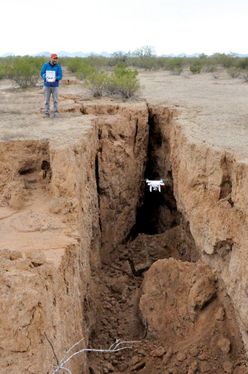
Brian Gootee flies an AZGS drone.
Fissures result from excessive groundwater pumping, which causes the earth to subside and break along the surface. They often reach more than a mile in length and stretch wider than a city street; the biggest can be hundreds of feet deep. While they typically occur in remote areas and can go unnoticed for years, they’re dangerous to people and animals. They also present environmental problems because they divert rainwater that would otherwise spread across the landscape and funnel surface pollutants such as pesticides directly into the water table.
That’s why it’s so critical to keep close tabs on fissures. To get up close and personal with the huge cracks in the earth, the AZGS maintains a small fleet of drones, which have revolutionized fissure observation as well as other tasks like monitoring potential landslides and spotting erosion hotspots after wildfires.
Consider the early 1900s, when crews of geologists would trek into and spend weeks or months painstakingly documenting a site. Later, they began surveying with cameras tethered to helium balloons, but that, too, was slow, and the balloons were difficult to maneuver.
Today, scientists like AZGS Research Geologist Brian Gootee can dispatch drones to a site after breakfast and have the data — complete with remarkable 3-D imagery — before dinnertime. Among Gootee’s enviable chores is piloting drones over fissures, including the one spotted near Tator Hills by Joe Cook.
“Brian’s drone was a really neat tool to get a bird’s-eye view of the fresh fissure,” Cook says, “and his footage was really nice. Drone footage is much more dramatic than ground photos. When fissures are new, their walls are vertical and sharp. There is little vegetation growing along the fissure, so you can see them clearly.”
Behind the controls of a drone, Gootee is always seeking the tiny clues — minute cracks or shifting substrate — that tell where a fissure is headed. Most images are captured at elevations of 1,000 feet or less. “That gives you a nice, stable, photographer’s perspective of very detailed features,” he says. “Even airplanes can’t provide the perspective that a drone does.”
Besides the quality of the footage they return, drones offer impressive speed. Following heavy rains, for instance, they can quickly assess landslide-prone areas to determine the potential for an emergency. And soon, they will become more autonomous, allowing researchers to attend to other tasks while the preprogrammed devices buzz off to investigate sites.
For all these reasons, the use of drones in geology is exploding. The AZGS is now among more than 15 state agencies across the country using them to streamline otherwise costly and time-consuming fieldwork. In regions with extensive oil and gas drilling, for instance, drones hunt for dangerous abandoned wells. Elsewhere, they help find undiscovered paleontological sites and monitor critical public structures, such as dams and bridges.
Drones also offer geologists unprecedented information about landslide sites. “Every landslide has its own anatomy in shape and morphology,” Gootee says, “so we want to capture that.” The AZGS will soon release a statewide landslide database, providing priceless information for emergency officials across Arizona.
Massive wildfires, which are becoming more common, also provide work for drones: examining the burned debris and naked, erosion-ready slopes they leave behind. Following a fire, entire hillsides can wash away, dragging along branches and brush in a deadly slurry. The worst threat is from fires just before the deluges of monsoon season. “Then there is nothing protecting that burned landscape,” Gootee says. “Everything runs off very quickly.”
Drones are used to pinpoint areas most at risk so officials can concentrate their limited resources. “We go in and identify an area and say, ‘Here are some real hotspots that you can identify prior to runoff.’”
“Ideally, once an area is safe to go into, and you can capture it from above, we would identify whether the area has thicker or thinner soil,” says Gootee. “We also look for areas that have a stockpile of debris in proximity to stormwater runoff.”
Amazing as they are, drones do require a deft human touch — and operators who know what to look for. “They’re super-cool,” says Gootee. “But if you don’t have expertise to back it up, they’re useless.”
When they are teamed with human knowledge, however, the potential is dazzling. “We’re excited that we can now do things very quickly, on-demand and at very low cost,” says Gootee. “We can deploy very quickly and deliver quickly. What before took weeks and months now takes hours and days.
“Drones have really changed the way we do science.”
Today, scientists can dispatch drones to a site after breakfast and have the data — complete with remarkable 3-D imagery — before dinnertime.